|
ClimCalc is a simple model of physical and chemical climate for the
New England / New York region derived from statistical analysis of
weather station data and data from atmospheric deposition monitoring
networks. The model estimates mean monthly values for precipitation,
solar radiation, and minimum/maximum daily temperature as well as
wet plus dry deposition of atmospherically deposited sulfur and
nitrogen compounds for locations within the northeastern U.S.
Required inputs are latitude and longitude (in decimal degrees),
elevation, slope and aspect. The model was designed to capture the
dominant regional patterns in climate and atmospheric deposition and
does not address some local factors such as rainshadow effects,
proximity to large water bodies and elevation effects on dry
deposition.
|
|
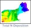

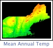 In addition to site-level estimates, ClimCalc has been used in
conjunction with a 1 km digital elevation model to yield monthly GIS
coverages (figure 1, also see references). This GIS data set
provided the basis for regional application of a carbon and water
balance model (PnET) aimed at predicting forest growth, water yield
and effects of future climate change.
In addition to site-level estimates, ClimCalc has been used in
conjunction with a 1 km digital elevation model to yield monthly GIS
coverages (figure 1, also see references). This GIS data set
provided the basis for regional application of a carbon and water
balance model (PnET) aimed at predicting forest growth, water yield
and effects of future climate change.


|